Republic of the Congo
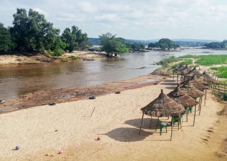
Bantu Beach
The Republic of the Congo is one of the most urbanized countries in Africa, with nearly 70% of Congolese living in urban areas. The population is concentrated in the southwest of the country, mainly in the capital Brazzaville, Pointe-Noire, and along the railway line that connects the two. The tropical jungles in the north of the country are sparsely populated. Most Congolese are Bantu, and most belong to one of four main ethnic groups, the Kongo, Teke, Mbochi, and Sangha, which consist of over 70 subgroups.
Country Profile
Official Name:
République du Congo
short form: Congo
int’l long form: Republic of the Congo
abbreviation: ROC, CGO
former: Middle Congo, Congo/Brazzaville, Congo
ISO Country Code: cg
Time:
Local Time = UTC +1h
Actual Time: Fri-July-16 09:47
Country Calling Code: +242
Capital City: Brazzaville (pop. 1 million)
Other Cities: Pointe-Noire (450 000), Dolisie (150 000), Djambala, Ewo, Impfondo, Madingou, Ouésso, Owando, Sibiti.
Government:
Type: Republic.
Independence: 15 August 1960 (from France).
Constitution: New constitution adopted in nationwide referendum on 20 January 2002.
Geography:
Location: Astride the Equator in west-central Africa, west of the Congo and Oubangui (Ubangi) rivers.
Area: 342,000 km² (132,000 sq. mi.)
Terrain: North-East: two thirds of the country are covered by equatorial forest, savanna in the south, coastal plains, fertile valleys, forested flood plains.
Climate: Tropical. (climate is equatorial with two reversed seasons–half of the country lies above, half below the Equator).
People:
Nationality: Congolese
Population: 4 million (2012 UN est.)
Ethnic groups: 15 principal Bantu groups: BaCongo, Vili, BaTeke, M’Bochi, and Sangha; more than 70 subgroups. A small population of Pygmies (less than 100 000), ethnically unrelated to the Bantu majority.
Religions: Traditional beliefs 50%, Christianity 45%, Muslim 2%.
Languages: French (official), Lingala and Munukutuba (national), Kikongo, Sangho, Lari, Vili.
Literacy: male: 89%, female: 78%
Natural resources: Oil, wood, potash, zinc, uranium, copper, phosphate, natural gas, hydropower.
Agriculture products: Cassava (tapioca), sugar, rice, corn, peanuts, vegetables, coffee, cocoa; forest products.
Industries: Petroleum extraction, cement, lumber, brewing, sugar, palm oil, soap, flour, cigarettes.
Exports partners: China 42.1%, Italy 16.9%, USA 4.9%, India 4.7%, Portugal 4.2% (2015)
Imports partners: China 20.3%, France 14.2%, South Korea 9.8%, USA 4.9%, UK 4.4%, Italy 4.1%, India 4.1% (2015)
Currency: Communaute Financiere Africaine franc (XAF)
Background

Inaugurated in 2016, the bridge’s real name is the Bridge of 15 August 1960. This is the date when the Republic of the Congo gained independence from France, and most people just refer to the bridge as “Independence Bridge” for short
The Republic of the Congo is named after the Congo River, whose name is derived from Kongo, a Bantu kingdom which occupied its mouth around the time of its discovery by the Portuguese in 1483[12] or 1484.[13] The kingdom’s name derived from its people, the Bakongo, an endonym said to mean “hunters” (Kongo: mukongo, nkongo).
During the period when it was colonized by France, it was known as the French Congo or Middle Congo. To distinguish it from the neighboring Democratic Republic of the Congo, it is sometimes referred to as Congo (Brazzaville) or Congo-Brazzaville. Brazzaville derives from the colony’s founder, Pierre Savorgnan de Brazzà, an Italian nobleman whose title referred to the town of Brazzacco, in the comune of Moruzzo, whose name derived from the Latin Brattius or Braccius, both meaning “arm”.
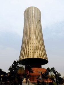
Nabemba Tower was the first skyscraper ever built in Brazzaville.
The Republic of the Congo was established on 28 November 1958 and gained independence from France in 1960. It was a Marxist–Leninist state from 1969 to 1992, under the name People’s Republic of the Congo. The sovereign state has had multi-party elections since 1992, although a democratically elected government was ousted in the 1997 Republic of the Congo Civil War, and President Denis Sassou Nguesso, who first came to power in 1979, has ruled for almost 4 decades.
The Republic of the Congo is a member of the African Union, the United Nations, La Francophonie, the Economic Community of Central African States, and the Non-Aligned Movement. It has become the fourth-largest oil producer in the Gulf of Guinea, providing the country with a degree of prosperity despite political and economic instability in some areas and unequal distribution of oil revenue nationwide. Congo’s economy is heavily dependent on the oil sector,[11] and economic growth has slowed considerably since the post-2015 drop in oil prices. With a population of 5.2 million, 88.5% of the country practices Christianity.
The Republic of Congo is one of Africa’s largest petroleum producers, but with declining production it will need new offshore oil finds to sustain its oil earnings over the long term.
The capital, Brazzaville, is located on the Congo River, in the south of the country, immediately across from Kinshasa, the capital of the Democratic Republic of the Congo.
The southwest of the country is a coastal plain for which the primary drainage is the Kouilou-Niari River; the interior of the country consists of a central plateau between two basins to the south and north. Forests are under increasing exploitation pressure. Congo had a 2018 Forest Landscape Integrity Index mean score of 8.89/10, ranking it 12th globally out of 172 countries.
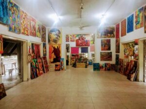
This painting school was founded in 1951 by a French mathematician and amateur painter named Pierre Lods. It’s a rather unorthodox school, where the teachers refrain from teaching as much as possible.
Instead, they encourage their students to expand their own creativity and originality. Currently, there are 7 professional painters working here and about 20 students who tend to come and go.
Congo lies within four terrestrial ecoregions: Atlantic Equatorial coastal forests, Northwestern Congolian lowland forests, Western Congolian swamp forests, and Western Congolian forest-savanna mosaic. Since the country is located on the Equator, the climate is consistent year-round, with the average day temperature a humid 24 °C (75 °F) and nights generally between 16 °C (61 °F) and 21 °C (70 °F). The average yearly rainfall ranges from 1,100 millimetres (43 in) in the Niari Valley in the south to over 2,000 millimetres (79 in) in central parts of the country. The dry season is from June to August, while in the majority of the country, the wet season has two rainfall maxima: one in March–May and another in September–November.
Culture
The Republic of the Congo also has large untapped base metal, gold, iron, and phosphate deposits. The country is a member of the Organization for the Harmonization of Business Law in Africa (OHADA). The Congolese government signed an agreement in 2009 to lease 200,000 hectares of land to South African farmers to reduce its dependence on imports
The Republic of the Congo has a wide variety of natural landscapes, ranging from the savanna plains in the North Niari flooded forests, to the vast Congo River, to the rugged mountains and forest of Mayombe, 170 km of beaches along the Atlantic coast. The numerous ethnic groups, forms of art, and political structures express a rich cultural diversity.
Among the best known are Vili nail fetishes, Beembe statuettes that are full of expression; the masks of the Punu and Kwele, Kota reliquaries, Teke fetishes, and cemeteries with monumental tombs are examples of this variety. The Lari people also have unique artifacts.

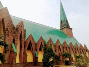
The Republic of the Congo also has considerable colonial architectural heritage, which it is preserving. Restoration of architectural works is underway in Brazzaville, for example, at the Basilica of Sainte-Anne du Congo, which was completed in 2011.
Because of problems with the communications network, the country is not ready to build on heritage tourism. It is working to improve the network that supports its hotels and related tourism facilities in Pointe Noire and Brazzaville. Many sites are difficult to reach in overland visits. Some of the South’s most populous and developed locations are often the least accessible. For example, the massive Chaillu Mountains are almost impossible to visit.
Sources: Wikipedia, Britannica, Cia.gov/the-world-factbook, Nationonline.com, google, https://www.thenomadicvegan.com/things-to-do-in-brazzaville-congo/