Some Facts about Africa
Countries of Africa

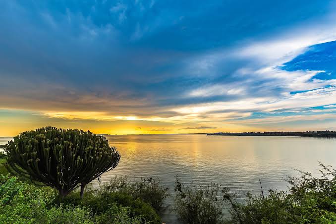
Fishermen on Lake Victoria. Africa’s largest lake is shared by three countries, Kenya, Uganda, and Tanzania.
Image: Khanairobi
African Regions
Conventionally there are five main geographical regions or subregions in Africa.
North AfricaWest AfricaCentral AfricaEast AfricaSouthern Africa
Some Facts about Africa

Africa is the second-largest continent in the world in both area and population. It is an almost entirely isolated landmass with only a small land bridge in the northeast, connecting the African Mainland with Western Asia.
Area
Africa covers six percent of the world’s total surface area, roughly 30,244,000 km² (11,700,000 mi²). Including its adjacent islands, the continent occupies about 20 percent of Earth’s total land area. Africa’s largest country is Algeria, followed by the Democratic Republic of the Congo(Kinshasa), and Sudan.
How many countries are there in Africa?
48 countries share the area of mainland Africa, plus six island nations are considered to be part of the continent. All in all, there are 54 sovereign African countries and two disputed areas, namely Somaliland and Western Sahara (see the list of African countries below).
Population
An estimated 1.34 billion people live in the second-largest continent, representing about 14 percent of the world’s population (as of 2020). By far the most populous country in Africa is Nigeria, with a population of more than 190 million.
(Source: UN World Population Prospects)
(1000)
North Africa or Northern Africa |
||||
 Assekrem, a high plateau in the Hoggar Mountains, the region is part of the Cultural park of Ahaggar (mountains) near Tamanrasset in southern Algeria. Image: Mohammed Amri |
||||
| North Africa or Northern Africa (as used by the United Nations) refers to the portion of Africa along the coast of the Mediterranean Sea (except for Sudan). In the northwest, the Atlas Mountains dominate the area. South of the Mediterranean coastal strip stretches the Sahara from the Atlantic Ocean in the west to the Red Sea in the east.
There are six countries in Northern Africa and one disputed territory, Western Sahara. According to the United Nations Population Division, approximately 242 million people live in Northern Africa (in 2019). |
||||
| Algeria | 42,679 | Algeria Map | Algiers | |
| Egypt | 101,169 | Egypt Map | Cairo | |
| Libya | 6,570 | Libya Map | Tripoli | |
| Morocco | 36,635 | Morocco Map | Rabat | |
| Sudan | 42,514 | Sudan Map | Khartoum | |
| Tunisia | 11,783 | Tunisia Map | Tunis | |
| Western Sahara | 582 | see: Mauritania Map | (El Aaiún) | |
West Africa or Western Africa |
||||
 Aerial view of Bargny, a coastal fishing town in the Rufisque Département of Senegal. The city is located on the south coast of the Cap-Vert peninsula, about 15 km to the east of Senegal’s capital, Dakar. Image: Peter A Harrison |
||||
| West Africa or Western Africa mostly refers to the countries north of the Gulf of Guinea in the north-western part of the continent. West Africa is located in the southern part of the so-called hump of Africa; it is bounded in the north by the Sahara desert and the Sahel zone. There are sixteen countries in West Africa and one British Overseas Territory, Saint Helena. According to the United Nations Population Division, an estimated 392 million people live in West Africa (in 2019). |
||||
| Benin | 11,802 | Benin Map | Porto-Novo, Cotonou | |
| Burkina Faso | 20,322 | Burkina Faso Map | Ouagadougou | |
| Cape Verde | 560 | Cape Verde Map | Praia | |
| Côte d’Ivoire (Ivory Coast) | 25,531 | Ivory Coast Map | Yamoussoukro, Abidjan | |
| Gambia, The | 2,228 | see: Senegal Map | Banjul | |
| Ghana | 30,100 | Ghana Map | Accra | |
| Guinea | 13,400 | Guinea Map | Conakry | |
| Guinea-Bissau | 1,954 | Guinea-Bissau Map | Bissau | |
| Liberia | 4,978 | Liberia Map | Monrovia | |
| Mali | 19,689 | Mali Map | Bamako | |
| Mauritania | 4,661 | Mauritania Map | Nouakchott | |
| Niger | 23,177 | Niger Map | Niamey | |
| Nigeria | 200,962 | Nigeria Map | Abuja | |
| Saint Helena (UK) | 4.5 | Jamestown | ||
| Senegal | 16,744 | Senegal Map | Dakar | |
| Sierra Leone | 7,883 | Sierra Leone Map | Freetown | |
| Togo | 8,186 | Togo Map | Lomé | |
Central Africa (Middle Africa, or also Equatorial Africa) |
||||
 Kalandula water fall at the Lucala River in the Malanje Province of Angola. Image: L.Willms |
||||
| Central Africa or Middle Africa (as used by the United Nations) refers to the tropical central portion of the African continent. There are nine countries in Central Africa, including the island nation of São Tomé and Príncipe.
According to the United Nations Population Division, approximately 174 million people live in Central Africa (in 2019). |
||||
| Angola | 31,788 | Angola Map | Luanda | |
| Cameroon | 25,313 | Cameroon Map | Yaounde | |
| Central African Republic | 4,826 | Central African Republic Map | Bangui | |
| Chad | 15,814 | Chad Map | N’Djamena | |
| Congo, Rep. (Brazzaville) | 5,542 | Congo, Rep. Map | Brazzaville | |
| Congo, Dem. Rep.(Kinshasa) | 86,728 | Congo, Dem. Rep. Map | Kinshasa | |
| Equatorial Guinea | 1,360 | Equatorial Guinea Map | Malabo | |
| Gabon | 2,109 | Gabon Map | Libreville | |
| São Tomé & Príncipe | 213 | São Tomé | ||
East Africa |
||||
 Rothschild’s giraffe at the White Nile out of Lake Albert in the Murchison Falls National Park in Uganda. The Rothschild’s giraffe is found in southern Sudan, northern Uganda and western Kenya. Image: Bernard DUPONT |
||||
| East Africa or Eastern Africa, is the eastern portion of the African continent; it includes Madagascar and other, smaller islands. In a narrower sense, the term East Africa may refer to the former British colonial areas of present-day Kenya, Tanzania, and Uganda. According to the United Nations Population Division, roughly 445 million people live in East Africa (in 2019). |
||||
| Burundi | 11,576 | Map of Burundi | Bujumbura | |
| Comoros | 851 | Map of Comoros | Moroni | |
| Djibouti | 986 | Map of Djibouti | Djibouti | |
| Eritrea | 5,310 | Map of Eritrea | Asmara | |
| Ethiopia | 110,136 | Map of Ethiopia | Addis Ababa | |
| Kenya | 52,215 | Map of Kenya | Nairobi | |
| Madagascar | 26,970 | Map of Madagascar | Antananarivo | |
| Malawi | 19,719 | Map of Malawi | Lilongwe | |
| Mauritius | 1,271 | Map of Mauritius | Port Louis | |
| Mozambique | 31,409 | Map of Mozambique | Maputo | |
| Réunion (France) | 890 | Map of Réunion | Saint Denis | |
| Rwanda | 12,794 | Map of Rwanda | Kigali | |
| Seychelles | 96 | Map of Seychelles | Victoria | |
| Somalia and Somaliland | 15,636 | Map of Somalia | Mogadishu | |
| South Sudan | 13,263 | see: Sudan Map | Juba | |
| Tanzania | 60,914 | Map of Tanzania | Dodoma, Dar es Salaam | |
| Uganda | 45,712 | Map of Uganda | Kampala | |
| Zambia | 18,137 | Map of Zambia | Lusaka | |
| Zimbabwe | 17,297 | Map of Zimbabwe | Harare | |
Southern Africa |
||||
 Gigantic sand dunes in the Namib-Naukluft National Park in Namibia. Image: Yathin S Krishnappa |
||||
| Southern Africa is the southern portion of the African continent, bounded by the South Atlantic Ocean in the west and the Indian Ocean in the east. The United Nations geoscheme lists five countries in Southern Africa, with a total population of about 67 million people (in 2019). | ||||
| Botswana | 2,375 | Botswana Map | Gaborone | |
| Lesotho | 2,293 | Maseru | ||
| Namibia | 2,642 | Namibia Map | Windhoek | |
| South Africa | 58,065 | South Africa Map | Pretoria, Bloemfontein, Cape Town | |
| Swaziland | 1,415 | Swaziland Map | Mbabane, Lobamba | |
More about Africa
Highest Point

Picture postcard image of an elephant herd at Amboseli National Park with Mount Kilimanjaro in background.
Image: Amoghavarsha
Africa’s highest mountain is located in Tanzania. The three million year old stratovolcano Mount Kilimanjaro has a height of 5,895 m (19,340 ft). The mountain has three volcanic cones Kibo, Mawenzi, and Shira. Uhuru Peak on Kibo is the mountain’s highest point.
The Batian peak of Mount Kenya at 3,825 m (12,549 ft) is Africa’s second-highest mountain.
Largest Lake
Lake Victoria or Victoria Nyanza is the largest of the African Great Lakes and the second-largest freshwater lake in the world. The source of the Nile River has a surface area of 68,800 km² (26,600 sq mi); it is shared by Uganda, Kenya, and Tanzania. [1]
Longest River
Africa’s longest river is the Nile; it is with 6,695 km, also the longest river in the world. The Nile flows from its source south of the equator through eleven countries and empties into the Mediterranean Sea.
Languages of Africa
There are about a thousand languages spoken on the continent, classified in four (or six) major language families:
Afro-Asiatic (e.g., Berber language), Nilo-Saharan, Niger-Congo (Bantu), and Khoi-San. (see also: Languages of Africa)
Physical Regions
Major physical regions in Africa are the Atlas Mountains, the Sahara Desert, the semiarid Sahel, the tropical Sudanian Savanna, also known as the African Savanna, the Nile and the Congo rivers, the Victoria Falls, the Ethiopian Highlands, the Ituri Rainforest in Central Africa, the African Great Lakes, the Great Rift Valley, the Namib, and the Kalahari deserts.
keywords: countries of Africa, population of Africa, destination Africa, travel Africa, capitals Africa, Central Africa, North Africa, Southern Africa, East Africa.